The Cabeçó d’Or, summit & loop hike via PR-CV 2

Hiking route to one of the most emblematic and visited peaks of Alicante.

Cabeco d'Or hiking trail
The Cabeçó d'Or, from the old town of Busot

The Cabeçó d’Or is probably the most emblematic mountain in the region of l’Alacantí and, without a doubt, one of the most visited in the province of Alicante.

Its imposing presence, with an intricate orography crossed by ridges and spurs, is visible from the entire region, being its hallmark and omnipresent backdrop to our beaches, such as San Juan/Muchavista.

Today we are going to make the “classic” circular route in the heart of this mountain range, with the option of ascending to its summit : an excellent viewpoint of the province at 1,209 meters high. We will do all of this by following the path of the PR-CV 2 short-distance trail, one of the “oldest” routes in Alicante.

In addition, we will try to find out the reason for the name of the mountain, and if it really hides a treasure inside. Put on your boots, grab your backpack, and get ready, today we leave…

"In search of the Gold of the Cabeçó"

Sierra del Cabeçó d'Or at sunset
West Slope of Cabeçó d'Or, at sunset
Index of contents

Route Summary

Cabeçó d'Or Hiking Route
Signaling of the trail PR-CV 2

We start from the car park located near the Cuevas del Canelobre, in the so-called Pla de la Gralla . From here, I personally recommend doing the circular route in an anti-clockwise direction, to leave the easiest part for last.

From Pla Cabeçó , we will climb the south face of the mountain range to Casa del Polset , where the final ascent to the summit begins, along a round trip path. Back in Polset, we return to the circular path to descend through the surprising Racó de Seva , a shady area with varied vegetation. Finally, a dirt track will take us to close the circle, ending today’s route.

DATA SHEET

Original publication date of this article: March 2008. Updated in March 2021.

The Cabeçó d'Or, a Sanctuary for Birds

royal-eagle-wikipedia
Golden Eagle. Photography by Juan lacruz - Own work, CC BY 3.0

It is important to note that the Cabeçó d’Or is a protected natural area that is part of the Natura 2000 Network (European protected areas) as a ZEPA (Special Protection Area for Birds). Specifically, the ZEPA ” Cabeçó d’Or i la Grana “.

Unique bird species live and breed in the Cabeçó d’Or, such as the Golden Eagle . Please keep this in mind during your visit and avoid conduct that could cause them discomfort. Thanks!

The origin of the toponym "Cabeçó d'Or"

Hiking Route Cabeçó d'Or, PR-CV 2

According to what we read on the “Senda y Leyendas” website, the origin of the name of this mountain would not come from gold, but from water . A quite probable version maintains that the Iberian toponym UR (water) ended up being confused with the Valencian OR (gold), giving rise to an unsuccessful search for the precious metal in the mountains, with the opening of various mines (unsuccessfully) in its skirts.

Thus, water would be the true treasure of Cabeçó, as confirmed by the springs that once sprouted on its eastern slope, giving rise to the town of Aigües, and its famous Spa, built in the 19th century, and today in a sorry state of disrepair. abandonment. The Cuevas del Canelobre are also an example of how water has shaped this great limestone relief of Jurassic origin in an almost magical way.

Busot, cultural visit

With the excuse of going to Busot to do the Cabeçó d’Or hiking route, it is well worth spending a little more time to visit and get to know this town, with a privileged location between the sea and the mountains.

As essential we could describe the visit to the Cuevas del Canelobre with its magnificent interior vault seventy meters high, and the curious calcareous formations that decorate it.

Busot offers multiple restaurants where you can taste the rich gastronomy of the area. For lovers of hiking, the Sierra de Alicante Boutique Hotel is a rewarding experience, as each of its rooms is themed and dedicated to the different mountains in the province of Alicante.

The little ones in the house will undoubtedly enjoy the Busot treasure hunt activity. For more information, be sure to visit the Busot tourism website.

Route Description

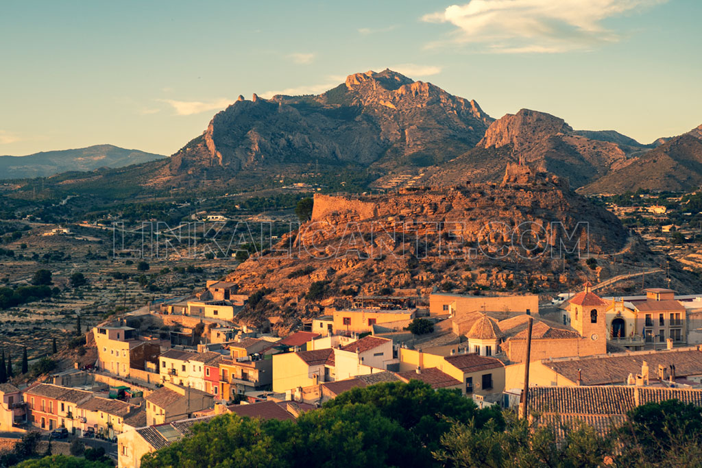
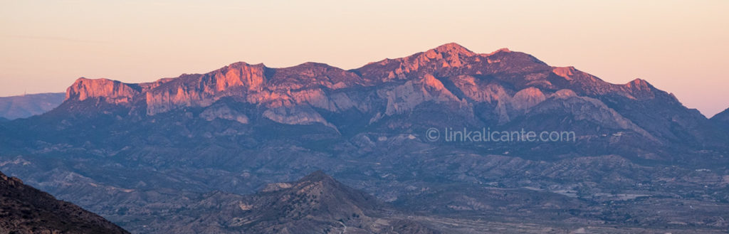
The Cabeçó d’Or was my second great summit in Alicante, after the Maigmó, and the one that ended up awakening in me the hiking spirit and the unconditional love for the mountain, back in the distant 2002.

Hiking trail Cabeçó d'Or, PR-CV 2

On the technical sheet, clarify that the time data are obviously approximate . It will depend on the rhythm of each one, the rush, the stops to take photos (which in my case are many), etc, etc. Personally, I like to go to the mountains without rushing, enjoying every corner.

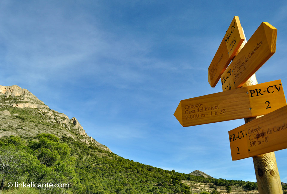
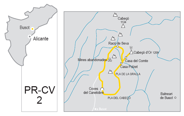
Start from the Pla de la Gralla

Hiking trail Cabeçó d'Or, PR-CV 2
The hole known as “El Pet de la Reina”, in the “Cresta de les Coves” or “Esquenall de la Foradada”

In a sharp curve of the access road to the Cuevas del Canelobre , we find the parking and information panel of the PR-CV 2. Here we parked the car ( careful not to leave belongings in sight), and we began to walk following the road in an ascending direction, in the direction of the caves. We continue to the end, where we find a small esplanade with picnic tables. From there starts a path that descends in a zig-zag, and that takes us to Pla Cabeçó .

Another option is to descend following the paths opened by mountain bikers on the western slope of the mountain, passing through the lower part of the entrance to the caves and connecting with the PR later.

Going up from Pla Cabeçó

Hiking trail Cabeçó d'Or, PR-CV 2
Views towards Serra del Cid, Serra del Maigmó and Penya Migjorn

In this first part of the route, we will gain height by zigzagging between repopulated pine trees. The path timidly heads towards Coll de la Castellana, located between Alt del Salmitre and Cabeçó itself.

Curve after curve, we are gaining height. From here you can see part of the Quarry that is destroying the southeastern part of the Salmitre . I think it’s a shame that things like this are allowed.

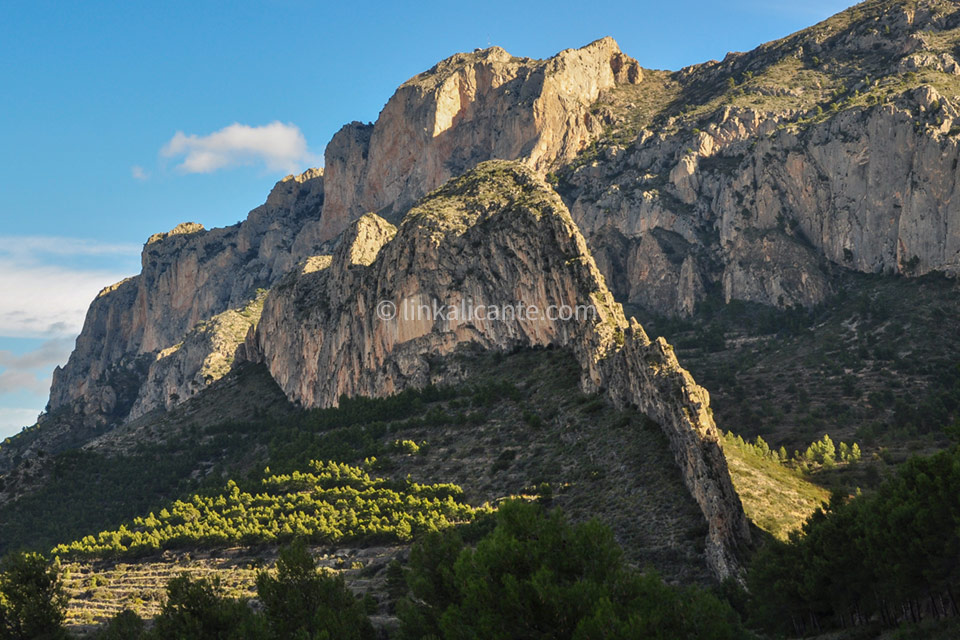
We continue climbing, we are already above the Salmitre. Above us there are a couple of very striking rocks, the Penya del Frare and, higher up, the Penya Redona , which is easily distinguished by its shape.

When we are under the Penya del Frare, after passing through a natural “viewpoint”, the path changes pace: the ascent becomes smoother, and we move practically flat towards the interior of the mountain range.

We pass under the Penya Redona, in an area without zig-zag, going up slightly. Before reaching the hill where Casa Polset is located, we have one last effort left. We pass under some larger pine trees, in a fairly leafy stretch.

Polset House

Hiking trail Cabeçó d'Or
Casa Polset, on the landing at the foot of the summit

On the wide hill where Casa Polset and an old snowfield are located, we take the opportunity to eat something and recharge our batteries, before starting the final climb to the top. We are at about 950 meters of altitude.

If we are tired or the weather is bad, we can skip the climb to the summit, and continue along the circular route.

Summit of the Cabeço d’Or

Hiking trail Cabeçó d'Or
Views towards Puig Campana from the summit of Cabeçó d’Or

From Polset, we begin the ascent to the summit. The trail heads north, almost in the same direction as the one that goes down to Racó Seva, but ascending. This part is very eroded , and there are many small variants, although in the end they all end up in the same place.

To avoid damaging the environment, deteriorating the vegetation and minimizing erosion, it is very important to try to follow the “official” path and avoid the quarries at all costs .

At first we cross a quarry area, with steep slopes where it is easy to slip. Thus we reach a section where we will walk at the base of a large rocky ledge. Shortly after, a step awaits us where it will be necessary to leave the poles and use the hands. It is the so-called “Hillary Step”, which has recently been equipped with staples.

We pass by a kind of abyss, and a quite vertical section where we can help each other with our hands. Just after which we reach the chordal or somital ridge, and the views open up to the east. From here, we will go up this side of the mountain, moving away from the cliffs on the west face, which we have been coming up until now. Again, this area is heavily eroded . Try to follow the official trail to minimize the impact on the mountain.

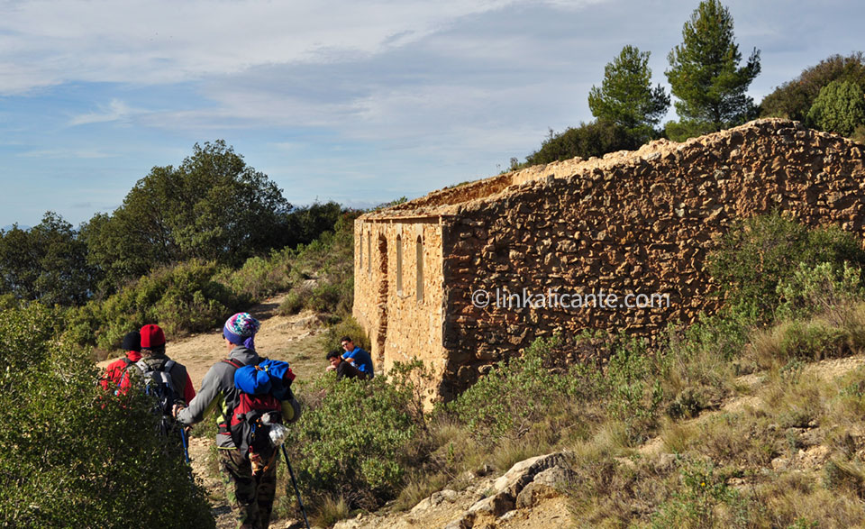
We arrive at the ruins of the Casa del Compte . Only a few steps separate us from the long-awaited conquest. Finally, we reach the summit of Cabeçó d’Or, at 1,209 meters high.

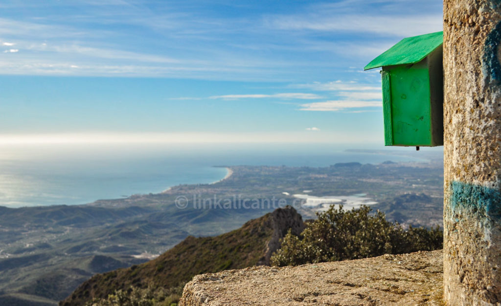
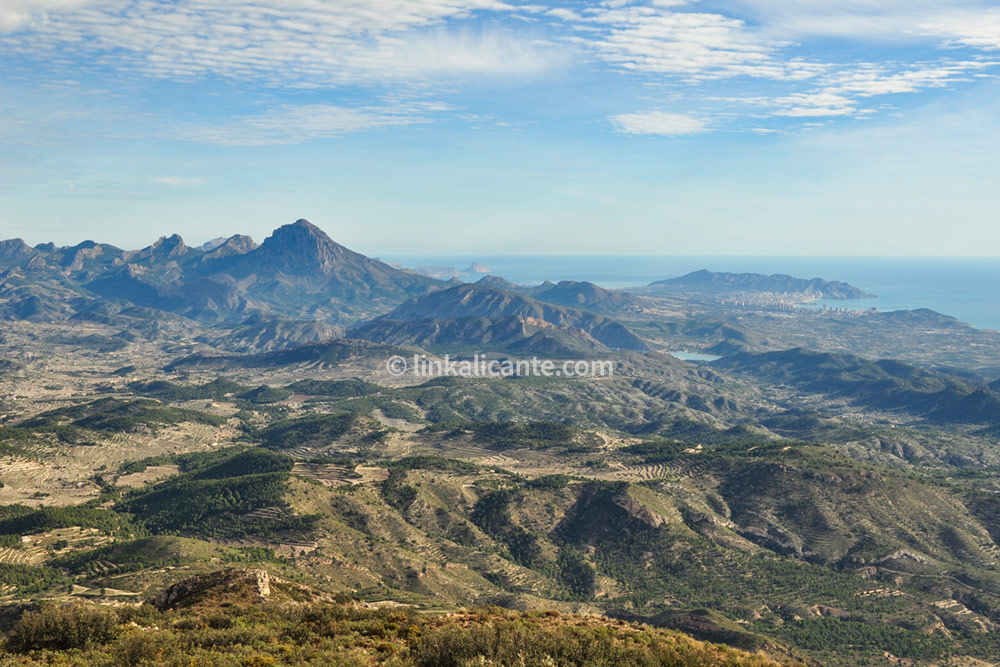
The panoramic view is impressive : to the south, Playa de San Juan/Muchavista, Cabo de la Huerta, Alicante city… Further north, Benidorm and the Serra Gelada, the Puig Campana, the Serra d’Aitana… Inland, the Serra dels Plans, the Penya Migjorn, the Maigmó… They say that on clear days you can see the mountains of Ibiza from up here, I haven’t had any luck yet…

Return through the Racó de Seva

Hiking trail Cabeçó d'Or, PR-CV 2
The impressive crest of l’Esquenall de l’Ase, and the walls of Cabeçó

We enter one of the most beautiful parts of the route. From Casa Polset, we begin the descent along the zig-zag path. Despite being very damaged by the continuous shortcuts, it takes us comfortably to Racó de Seva , passing by the impressive Esquenall de l’Ase . From there, it only remains to follow the dirt road to return to the starting point, ending this beautiful and demanding hiking route in Cabeçó d’Or.

We may not have found the long-awaited gold that they say the mountain hides, but without a doubt we return home enriched after this wonderful experience. Until next time!

Track for GPS

The circular route and the climb to the top is marked with the markings of the PR-CV 2 trail, although at some points the signage is very deteriorated or non-existent. To clear up doubts, I leave you the GPS track that you can follow through the wikiloc application.

Do not miss...

Links of interest

Dinos si te ha gustado

1 estrella2 estrellas3 estrellas4 estrellas5 estrellas (Sin valorar todavía)

Buenas Prácticas

• Sigue siempre los senderos. Atajar daña el entorno.
• Respeta flora, fauna y entorno. Disfruta en Silencio.
• No dejes rastro de tu paso, tampoco restos orgánicos.
• Infórmate, Planifica y Equípate bien para disfrutar al máximo.
• Respeta el Patrimonio Cultural (ruinas, márgenes de piedra, etc).
• Respeta a otras personas y propiedades privadas.

Leave a Comment

Your email address will not be published. Required fields are marked *

This site uses Akismet to reduce spam. Learn how your comment data is processed.

Scroll to Top